7-Day California Itinerary: Los Angeles, Big Sur & San Francisco Road Trip

A California itinerary covering Los Angeles, Big Sur, and San Francisco is arguably the greatest road trip in North America and, depending on who you ask, the world.
The Pacific Coast Highway (Highway 1) connecting these three destinations is 400 miles of the most visually dramatic driving anywhere on the planet: urban sprawl giving way to vineyard hills, then to rugged cliffs with the Pacific crashing hundreds of meters below, then to the fog-draped bay of one of the world’s most beloved cities.
Seven days is exactly enough time to do it properly, without rushing.
Carmel-by-the-Sea stages its Los Angeles sets the stage; its sprawl and energy and relentless ambition are the counterpoint to everything that follows.
Big Sur is the reversal: 90 miles of coastline so raw and unpopulated that it feels like the edge of the earth, with accommodations so limited that planning ahead is not optional. San Francisco is the reward at the end: compact, walkable, self-confident, and genuinely unlike any other American city.
The drive between them, stopping at Santa Barbara, Hearst Castle, Carmel-by-the-Sea, and Monterey, is the whole point.
budget; This guide is built on the experience of hundreds of travelers who have done this route, distilled into what actually works for a first-time visitor in seven days.
It covers the PCH honestly, including the current Highway 1 closure situation south of Lucia; gives you a realistic budget; and tells you what to book months in advance (Big Sur accommodation: that is your most critical booking of the entire trip).
Quick Facts: 7-Day California Road Trip:
- Total Distance: 400 miles (PCH/Hwy 1) · 550 miles via inland US-101 (faster alternative)
- Best Months: April–October · April–June for wildflowers · avoid July–August Big Sur crowds
- Sur/Gas tip: Fill up in Carmel before entering Big Sur; there are no stations for 30+ miles
- ahead: genuinely Big Sur Accommodation: Book 3–6 months ahead; it’s genuinely limited and fills completely in summer
- closed: Hwy 1 Closure (2025): The section south of Lucia is closed. Check Caltrans QuickMap before you go
- Daily Budget: $80–$120 (camping) · $150–$220 (mid) · $250–$400 (comfortable)
- Automatic iCar: Rent in LA, drop in SF (one-way fee applies) · Automatic is strongly recommended on PCH curves
- Download Mobile Signal: Virtually none in Big Sur. Download Google Maps offline before entering
The 7-Day Route – Overview
| hours day | Location | Drive | Key Experiences | Overnight |
|---|---|---|---|---|
| Day 1 | Arrive Los Angeles | – | Hollywood Sign · Getty Centre · Griffith Observatory | Los Angeles |
| Day 2 | Los Angeles | – | Santa Monica Pier · Venice Beach · LACMA · Sunset Strip | Los Angeles |
| Day 3 | LA → Santa Barbara | 2 hrs | Stearns Wharf · State Street · Santa Barbara Mission | Santa Barbara |
| Day 4 | Santa Barbara → Big Sur | 3.5 hours | Hearst Castle · Elephant seals San Simeon · Bixby Bridge | Big Sur |
| Day 5 | Big Sur (full day) | Local drives | McWay Falls · Pfeiffer Beach · Pfeiffer Big Sur hike · Nepenthe | Big Sur |
| Day 6 | Big Sur → San Francisco | 3.5 hours | 17-Mile Drive · Carmel · Monterey Aquarium | San Francisco |
| Day 7 | San Francisco | – | Golden Gate Bridge · Alcatraz · Fisherman’s Wharf · Cable car | Depart SF |
Day-by-Day California Itinerary
Day 1: Los Angeles
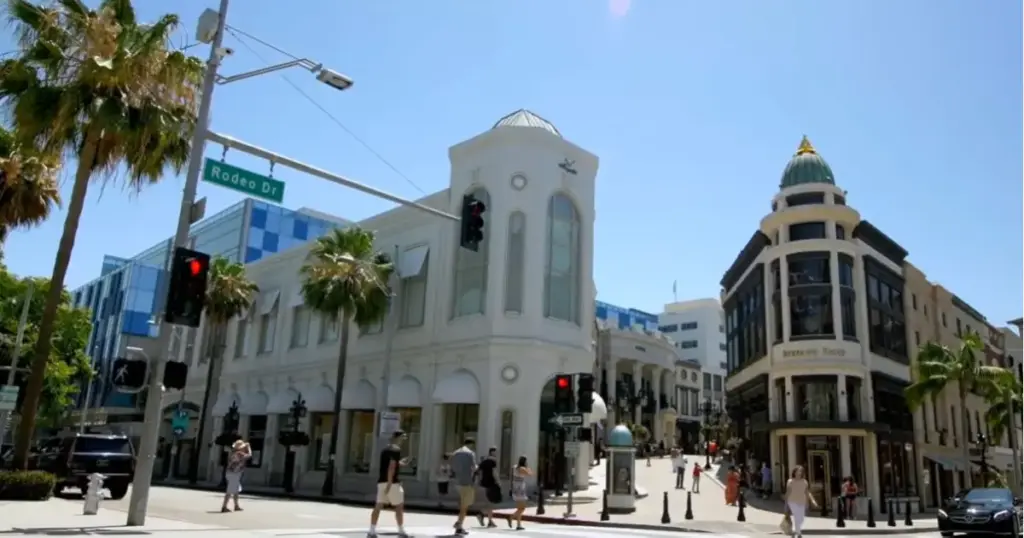
Los Angeles defies easy summary; it is 500 square miles of distinct neighborhoods, each with its own personality, connected by one of the world’s most complex freeway systems.
For a first-timer on a seven-day road trip, the key is to pick two or three neighborhoods and go deep rather than attempting to drive across the city all day. Traffic in LA is genuinely brutal during rush hours (7–9am and 5–7pm); plan your movement around these windows.
The Getty Center, perched on a hillside above Bel-Air with panoramic views across the city to the Pacific, is free to visit (parking is $20) and houses one of the finest art collections in the United States. The Impressionist and Post-Impressionist holdings are world-class.
Griffith Observatory, also free, sits in Griffith Park above Hollywood and delivers the most iconic view of the Los Angeles basin. The Hollywood Sign is clearly visible from the observatory terrace.
Coexist, Santa Monica, and Venice Beach are worth a full afternoon. The Third Street Promenade, the pier with its small Ferris wheel, and the Venice Boardwalk, where street performers, bodybuilders (Muscle Beach), and the perpetual California outdoor culture all coexist, are quintessentially LA experiences that no itinerary should skip.
Day 1 – Suggested Plan
- Arrive LAX · collect rental car · check in to hotel
- Getty Center (free, timed parking reservation required) 2.5 hours
- Griffith Observatory at sunset for the Hollywood Sign view and city panorama
- Dinner in Los Feliz or Silver Lake neighbourhood
Day 2: Suggested Plan
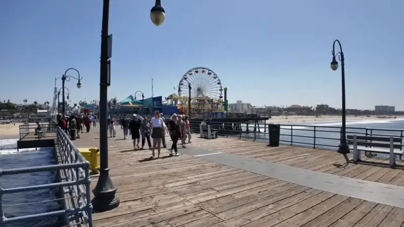
- Morning: Santa Monica Pier and beach (arrive before 10am for parking)
- 11am to 2pm. Venice Beach Boardwalk: The street performer scene peaks from 11am to 2pm.
- Art), the largest Afternoon: LACMA (Los Angeles County Museum of Art), the largest art museum in the western US; free Thursday evenings
- Sunset: Mulholland Drive scenic overlook above Beverly Hills for city views
- Evening: The Grove / Farmers Market in Fairfax district for dinner
LA First-Timer Tips:
Traffic is the worst. 7–9am and 4–7pm on weekdays; plan major drives outside these windows
Parking in Santa Monica: Pier parking garage on 2nd Street is the most convenient ($3/hr)
The In-N-Out Burger on Sepulveda Blvd near LAX is a California institution worth the queue
Rideshare (Uber/Lyft) is often faster and cheaper than driving + parking in Hollywood and West Hollywood
Download the LA Metro app. The E line connects downtown to Santa Monica and is genuinely useful
Day 3: Santa Barbara
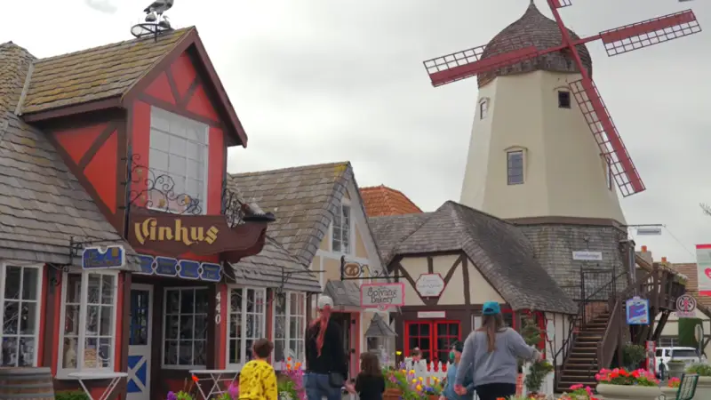
The drive north from Los Angeles on the US-101 takes about two hours to Santa Barbara, a city of Spanish mission architecture, white stucco buildings with red tile roofs, a laid-back atmosphere, and a surprisingly impressive wine country immediately behind it in the Santa Ynez Valley.
Santa Barbara is consistently ranked among the most beautiful small cities in California, and it serves as a perfect first overnight stop before the more remote Big Sur.
Harbor, Stearns Wharf, California’s oldest working wharf, extending into the Santa Barbara harbor, is a 10-minute walk from the downtown shops on State Street.
The Santa Barbara Mission, founded in 1786 and still an active parish church, is the most beautiful of California’s 21 Spanish missions and worth the $12 entry.
The view from the mission gardens back towards the mountains and the sea explains exactly why the Spanish chose this particular location.
Day 3 Plan:
- Depart LA early morning on US-101 North (2 hrs to Santa Barbara)
- Santa Barbara Mission ($12) 45 minutes; the architecture and gardens are exceptional
- harbor views Stearns Wharf: Walk to the end for harbor views and fresh seafood at the wharf restaurants
- State Street afternoon browse boutiques, galleries, the Santa Barbara Museum of Art (free on Sundays)
- (evening): the Santa Barbara Funk Zone (evening), the converted warehouse arts and wine district; excellent craft beer and natural wine bars
Day 4: Santa Barbara to Big Sur via Hearst Castle
trip; today’s drive is the most varied of the trip. It transitions from the Santa Barbara wine country through the agricultural Central Coast, up to San Simeon and Hearst Castle, then north into the southern approaches of Big Sur as the highway begins its dramatic coastal climb.
Hearst Castle at San Simeon is one of California’s most extraordinary historic properties, a 165-room estate built by newspaper magnate William Randolph Hearst and filled with European antiques, paintings, and architectural fragments he bought by the crate.
Timed entry tours depart from the visitor center and run about 45 minutes to 1 hour. Buy tickets in advance; day-of availability is possible but not guaranteed. A few miles south of San Simeon, the Piedras Blancas Elephant Seal Rookery is free and unmissable. 17,000 elephant seals haul out on the beach here year-round, and the viewing area boardwalk brings you within meters of them.
Simeon, Mountains, California, appears north of San Simeon; the PCH begins climbing into the rugged Santa Lucia Mountains, and the scenery transitions almost immediately into the Big Sur experience. Bixby Creek Bridge, the single most photographed bridge in California, appears roughly 13 miles south of Carmel.
The small pullout on the north side fills up quickly; arrive before 9am or after 4pm for a manageable stop and the best photography conditions.
Day 4 Plan:
- Depart Santa Barbara morning on US-101 North (1.5 hrs to San Luis Obispo area)
- Allows Hearst Castle, San Simeon (book tours at hearstcastle.org; $30). Allow 2 hours total
- Piedras Blancas Elephant Seal Rookery (free) 20 minutes; genuinely extraordinary
- North: Drive PCH north; the scenery begins here; stop at Ragged Point for the first dramatic cliff views
- (4 pm) (4 pm) (4 pm) (4 pm) Bixby Creek Bridge pullout (4 pm for golden hour photography if timing works)
- Check:accommodation; doaccommodation; doaccommodation; doCheck into Big Sur accommodation do not arrive after dark on your first night
Big Sur 2025 Highway 1 Closure Update:
As of early 2025, Highway 1 is closed between Lucia and Limekiln State Park due to landslide repairs
The northern section (Bixby Bridge south to Lucia) is fully open; all major sights are accessible
Check Caltrans QuickMap (quickmap.dot.ca.gov) for current road status before driving
Expected reopening: spring 2026, but timeline has shifted before; always verify
Coming from the south: take US-101 to Nacimiento-Ferguson Road to rejoin Highway 1 near Lucia
Day 5: Big Sur Full Day
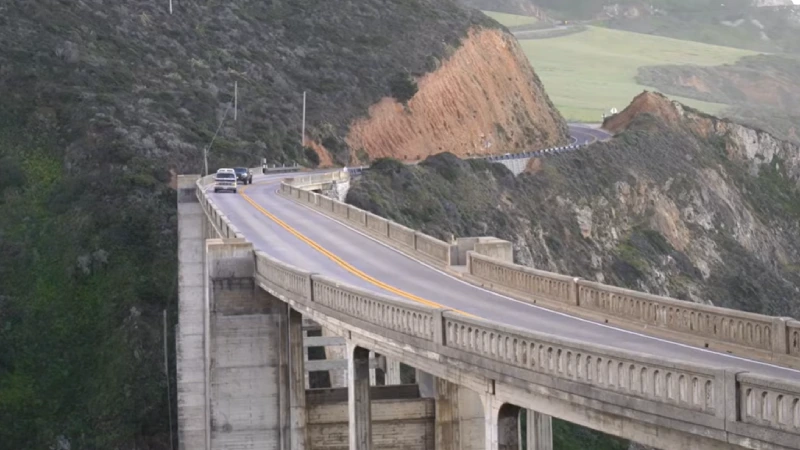
Big Sur is not a town. It has no traffic lights, no bank, and no strip mall; it is a state of mind and a 90-mile stretch of California coastline between Carmel in the north and San Simeon in the south, flanked by the Santa Lucia Mountains on one side and the Pacific on the other.
The landscape is what geologists call a collision zone, where the Pacific plate meets the North American plate, and the result is a coastline of violent beauty: sheer cliffs, sea stacks, redwood canyons running down to coves, and a permanent mist that gives the whole place an atmosphere of having been found rather than visited.
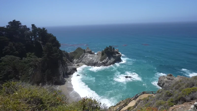
McWay Falls at Julia Pfeiffer Burns State Park is the most iconic single image in Big Sur, an 80-foot waterfall dropping directly onto a crescent beach accessible only to the ocean, visible from a short trail above. The car park fills by 9am in summer; arrive at or before 8am.
Pfeiffer Beach, a few miles north, is famous for its purple-tinged sand (manganese garnet washed down from the mountains) and a rock arch through which waves crash dramatically, one of the genuinely surreal beaches in California.
Day 5 Plan:
- Early morning: Julia Pfeiffer Burns State Park McWay Falls trail ($10 day-use fee; arrive before 9am)
- Mid-morning: Pfeiffer Big Sur State Park 2-hour hike on the Gorge Trail through redwood forest
- Noon: Lunch at Nepenthe restaurant (1,200 ft above the ocean; the view is among the finest in California; lunch is casual at Café Kevah below the main restaurant)
- Afternoon: Pfeiffer Beach purple sand and the rock arch; 2 miles down an unpaved road (narrow; standard cars are fine; large vans/RVs will struggle)
- Late afternoon: Soberanes Canyon Trail or Garrapata State Park bluff walk for sunset views
- Evening: Dinner at Big Sur Taphouse or back at your accommodation
Day 6: Big Sur to San Francisco via Monterey and Carmel
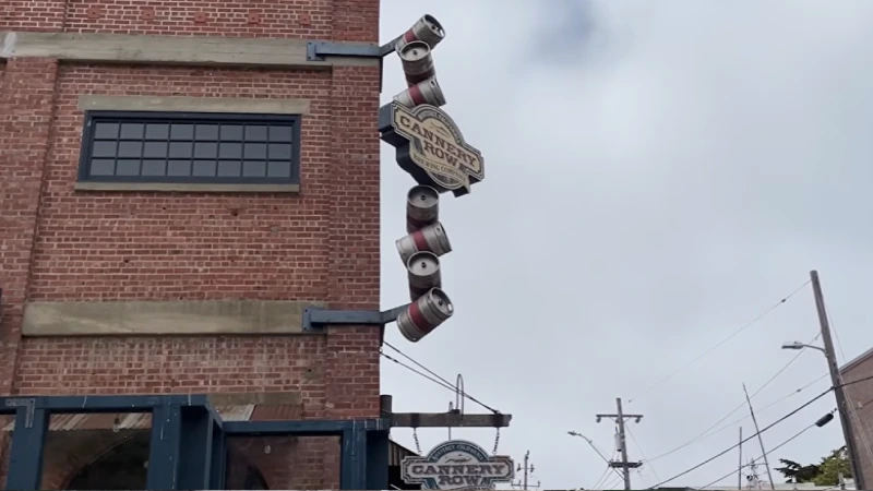
Leaving Big Sur northward on Highway 1 brings you into the Monterey Peninsula, a completely different California scene that is polished, affluent, and centered on one of the finest aquariums in the world.
The Monterey Bay Aquarium is not a typical tourist attraction; it is a world-leading marine research facility that opens a window onto the extraordinary biodiversity of the Monterey Bay National Marine Sanctuary. The sea otter exhibit alone is worth the price of admission.
The 17-Mile Drive through Pebble Beach is a private scenic road (entry fee $12.50 per car) that passes the Lone Cypress (the single most photographed tree in California, standing on a granite headland above the Pacific), several of the world’s most prestigious golf courses, and the rocky coastline of Pacific Grove, where monarch butterflies overwinter.
Carmel-by-the-Sea, immediately south of the 17-Mile Drive’s northern gate, is a village of art galleries, flower-box cottages, and restaurants that is genuinely charming without feeling contrived. Allow an hour for a coffee and a walk through the center before continuing north.
Day 6 Plan:
- Depart Big Sur early on Highway 1 North (1.5 hrs to Monterey)
- 17-Mile Drive, Pebble Beach ($12.50 entry) Lone Cypress viewpoint, Fanshell Overlook, Bird Rock
- Carmel-by-the-Sea: 1 hour walking the village; Ocean Avenue for lunch
- Monterey Bay Aquarium ($55 adults; book online) allows 3 hours; the sea otter viewing area and kelp forest tank are unmissable
- Cannery Row and Fisherman’s Wharf, Monterey 30-minute afternoon walk
- Drive US-1/US-101 north to San Francisco (2.5 hrs from Monterey); arrive in the evening
Day 7: San Francisco
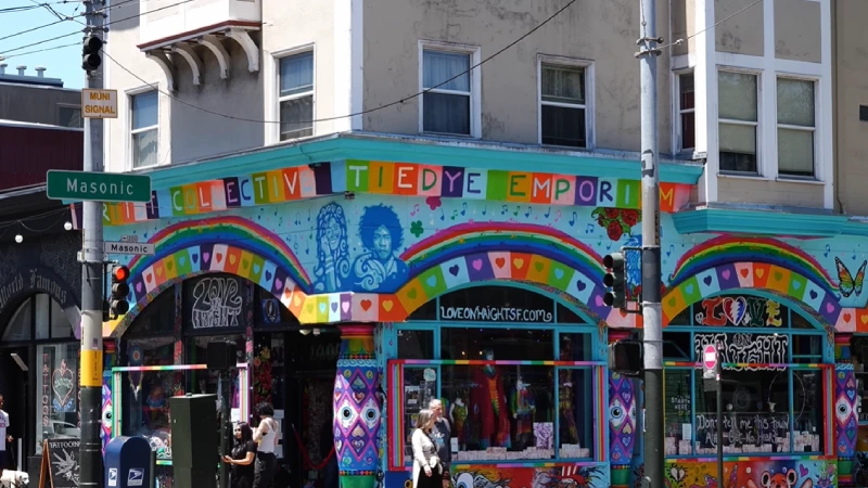
San Francisco compresses more per square mile than almost any other city in America. The Golden Gate Bridge, Alcatraz, the cable cars, Fisherman’s Wharf, the painted ladies of Alamo Square, the Mission District murals, Haight-Ashbury every neighborhood has a distinct identity, and every view is a postcard.
The city is small enough (roughly 7 miles by 7 miles) that determined walkers can cover enormous ground, though the hills, some exceeding 300 meters, provide a reliable cardio workout.
Alcatraz Island is the single most important advance booking on the entire San Francisco leg. Ferry tickets from Pier 33 sell out weeks ahead in peak season; book at alcatrazcruises.com as soon as you have confirmed travel dates.
The audio tour (narrated by former guards and prisoners) is exceptional, genuinely one of the best self-guided museum experiences in the United States. The evening ferry tour gives a different, atmospheric perspective on the bay and the city skyline.
The Golden Gate Bridge walk (1.7 miles one way from the east toll plaza to the Marin headlands side) takes about 45 minutes each way and delivers views that change constantly depending on whether the famous fog is rolling in or clearing.
The bridge is free to walk; the views from the Marin headlands on the north side, looking back at the bridge with San Francisco behind it, are arguably the finest in the city.
Day 7 Plan:
- Morning: Alcatraz Island (ferry from Pier 33; pre-book at alcatrazcruises.com; $45 adults including audio tour)
- Noon: Fisherman’s Wharf and Pier 39 sea lions on the K-dock, clam chowder in a sourdough bowl (Boudin Bakery)
- Afternoon: Golden Gate Bridge walk, drive, or take the 28 bus to the east toll plaza parking lot
- Late afternoon: Haight-Ashbury neighborhood, the epicentre of the 1960s Summer of Love; the Amoeba Music store and the Victorian painted lady houses on Ashbury Street
- Evening: Mission District for dinner, the most culturally vibrant neighbourhood in San Francisco; taquerias, natural wine bars, and the Clarion Alley murals
- Return rental car to SF drop-off; depart from SFO or Oakland Airport
San Francisco First-Timer Tips:
Book Alcatraz tickets immediately after confirming travel dates. Summer departures sell out 4–6 weeks ahead
The MUNI day pass ($23) covers all cable cars, buses, and streetcars an excellent value for a full sightseeing day
Cable car queues are longest at Powell & Market. Join at the turnaround at Powell & Bay for shorter waits
Golden Gate Bridge fog: the bridge is completely clear most mornings in May–June; afternoon fog rolls in from 1–2pm daily in summer
Park the car once in SF and use public transit. Parking is expensive and the city is far easier on foot and MUNI
Practical Information – PCH Driving, Budget and Accommodation
Driving the Pacific Coast Highway – What to Know
The PCH (Highway 1) through Big Sur is 35–55 mph and winds constantly; it is not a road for distracted driving. The views are extraordinary, but the drop to the ocean is real, and there are few guardrails in many sections.
Drive at the posted limit or below, use the official pullouts rather than stopping on the road itself, and never drive this section after dark if you can avoid it. The road is narrow and unlit, and the combination of curves and fatigue makes night driving genuinely dangerous.
Fuel: Fill up completely in Carmel before heading south into Big Sur or in Cambria before heading north. There are almost no gas stations in the 90-mile Big Sur section, and the few that exist charge premium prices. Running low on fuel in Big Sur is a genuinely stressful situation that is entirely avoidable.
Related Articles: USA East Coast Road Trip – NYC to Miami Complete Guide
Accommodation Along the Route:
| Destination | Budget Option | Mid-Range | Tip |
|---|---|---|---|
| Los Angeles | Hostel/Airbnb $40–$80 | Hotel $120–$200 | Stay in Santa Monica or Silver Lake for easy access |
| Santa Barbara | Motel $80–$120 | Hotel $140–$220 | Book Funk Zone area for walkability |
| Big Sur | Campground $35–$65 | Lodge $180–$350 | Book 3–6 months ahead genuinely scarce |
| Monterey/Carmel | B&B $100–$160 | Hotel $160–$280 | Carmel more walkable and charming than Monterey |
| San Francisco | Hostel/budget: $50–$90 | Hotel $140–$250 | Union Square or Fisherman’s Wharf for first-timers |
Budget Summary
| Cost Category | Budget | Mid-Range | Comfortable |
|---|---|---|---|
| Accommodation (7 nights) | $35–$90/night | $120–$250/night | $250–$500/night |
| Car rental (7 days, one-way) | $280–$420 | $420–$600 | $600–$1,000 |
| Gas (total 400 mi PCH) | $80–$100 | $80–$100 | $80–$100 |
| Meals (per day) | $25–$40 | $50–$80 | $90–$180 |
| Attractions (per day) | $15–$30 | $35–$65 | $70–$120 |
| TOTAL 7-day estimate | $1,200–$1,800 | $2,500–$4,000 | $4,500–$7,500+ |
Frequently Asked Questions
Q1. Should I drive the PCH from LA to SF or SF to LA?
Drive from LA to San Francisco (south to north). This keeps the ocean on your left (driver’s side), which means the most dramatic coastal views are directly in front of you, and passenger-side photography is natural. This direction is universally preferred by experienced PCH drivers.
Q2. Is Highway 1 through Big Sur open in 2025?
Partially. As of 2025, Highway 1 is closed between Lucia and Limekiln State Park due to ongoing landslide repair, with expected reopening in spring 2026. The northern section, which includes Bixby Bridge, McWay Falls, Pfeiffer Big Sur State Park, and all major visitor stops, is fully open. Always check Caltrans QuickMap for current status before your trip.
Q3. How far in advance should I book Big Sur accommodation?
Book 3–6 months ahead for summer travel (June–August) Big Sur has very limited accommodation, and it fills completely. For spring and autumn travel, 6–8 weeks ahead is usually sufficient, but earlier is always safer. This is the single most critical booking of the entire California trip.
Q4. Do I need a 4WD for Big Sur?
No. A standard rental car is fine for all the main Big Sur roads, including the unpaved road to Pfeiffer Beach. Large RVs and vans struggle on Pfeiffer Beach Road (very narrow), but any standard car handles it without issue. The PCH itself is paved throughout and does not require 4WD.
Q5. What is the best time of year for this California road trip?
April to June is the sweet spot; wildflowers are blooming across the hillsides, temperatures are pleasant, and the summer crowds have not yet arrived. September to October is excellent too: fog clears, crowds thin, and the coastal light is exceptional. July and August work, but Big Sur especially gets very busy and accommodation prices peak.
Q6. Can I do this trip without a car?
Los Angeles and San Francisco can both be explored without a car. Big Sur and the PCH cannot. There is no meaningful public transport between Carmel and San Simeon. A rental car is essential for this particular itinerary. If driving feels daunting, several operators run guided multi-day PCH tours that handle all driving and accommodation logistics.
Conclusion
Beach leave, seven days on this route leaves you with the kind of photographic memory that is specific to a road trip: the exact moment Bixby Bridge appeared around a curve; the sound of the McWay Falls water hitting that impossible beach; and the first sight of San Francisco Bay through the car window as the road curves north. It is a journey where the driving itself is as much the experience as any single destination.
Big Book of Big Sur accommodation first. Fill the tank in Carmel. Drive north, keep the ocean on your left, and stop at every pullout that looks interesting.
The best views on Highway 1 are often the ones not listed in any guide. The Pacific Coast Highway is one of the few roads in the world that genuinely lives up to its reputation. Seven days is the right amount of time to find out why.